Loading...

NYC Heritage Data Visualizations


How does one collapse multifaceted centuries and dynamics into a single image? Or map "heritage"? or visualize "culture"?

What is presented is a brief sampling of the larger scope of research and innovations in visualizations of NYC’s multifaceted manifestations of Heritage.

From printed pictorial maps to interactive dendrochronological metaphors, these offer insights on how data can compel stories that enrich and reveal.


Arthur Zaidenberg

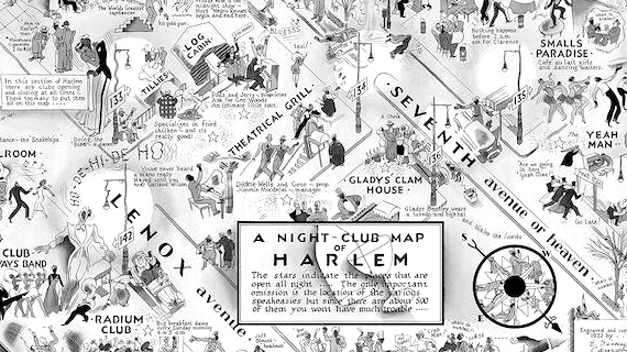
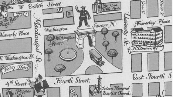
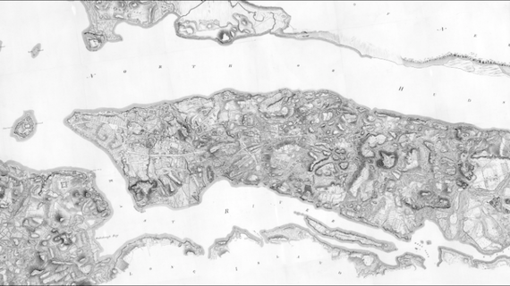
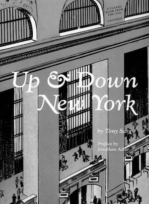
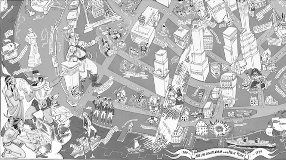
DOWNTOWN DISTRICT OF MANHATTAN, 1938

A whimsical pictorial aerial map of Lower Manhattan, filled with cartoon style illustrations depicting landmarks, figures and events from NYC colonial history and the early years of the American republic. A 1930s steamship time-travels into view.

Publication Date:
1938.

Data Source(s):
Illustrations.


Learn More
Elmer Simms Campbell

NIGHT CLUB MAP OF HARLEM, 1932

Every jazz club, entertainment, restaurant, and speakeasy in Harlem’s 1932. is shown on this witty cartoon map. Campbell frequented many of the establishments depicted, while befriending famous musicians celebrated here.

Publication Date:
1932.

Data Source(s):
Personal experiences.


Learn More
Herman Bollman

MIDTOWN MANHATTAN, 1962

Bollmann created this pictorial map of midtown Manhattan for the 1964 New York World’s Fair, with buildings rendered as a bird’s-eye view in isometric perspective.

Publication Date:
1962.

Data Source(s):
67,000 photographs (17,000 aerials, 50,000 ground. Each building hand drawn at 1:4,800 scale.


Learn More
James A. Kelly

Indian Villages, Paths, Ponds, and Places in Kings County

A map of Native American Indian trails traced by now-familiar Brooklyn roads highlights the hidden political and social stories behind the creation of Indigenous Cartography by European settlers and native peoples.

Publication Date:
1946.

Data Source(s):
Land transaction records.


Learn More
Tony Sarg

A Map of Greenwich Village

Fine example of Sarg's illustrations of important places, a guide to the locations of various restaurants, stores, bars, and the Whitney Museum of American Art at its original location. Portraits of Mark Twain and Washington Irving, former Greenwich Village residents. People shown in various activities include artists painting, a woman shopping, and performers in Union Square..

Publication Date:
1934.

Data Source(s):
Illustration.


Learn More
NICHOLAS FELTON

Annual Feltron Reports
(2005-2014)

A fascinating study of personal data tracking and a gorgeous piece of design, all based on information drawn from his memory, calendar, photos, and Last.fm data. a tapestry of graphs, maps and statistics to reflect the year's activities throughout NYC.

Publication Date(s):
2005-2014.

Data Source(s):
Private Data.


Learn More
NYC BigApps

NYC BigApps 2009

NYC BigApps is the annual flagship civic innovation challenge in New York City for designers, developers, academics, entrepreneurs, and New Yorkers at large to apply their know-how to improve the Big Apple. On its 2009 launch, the city will make available about 80 data sets from 32 city agencies and commissions.

Publication Date(s):
2009 - present.

Data Source(s):
NYC Open Government Data.


Learn More
Eric Sanderson

THE WELIKIA PROJECT

The Welikia Project aims at discovering the original ecology and landscape of New York City from 1609 and comparing it with what we have today. powerful update that now lets you explore the city’s historic ecology using a satellite map that imagines how Manhattan might have looked back in 1609—and all the years between then and now. Welikia: an online mapping database that lets visitors view what Manhattan was like more than 400 years ago. the basis for all the people of New York to appreciate, conserve and re-invigorate the natural heritage of their city not matter which borough they live in.”

Publication Date(s):
2010-2012.

Data Source(s):
1782 British Headquarters Map, Soil Core, Field Work, 1609 Abiotic Data Set, Muir Web, et. al.


Learn More
David Hughes

UNION SQ GREENMARKET MAPS

As then-Operations Manager (2007-2017) of GrowNYC’s flagship Union Square Greenmarket, Hughes designed a currently-used template and series of regularly-printed vendor maps highlighting ebbs and flows of farmers seasonal produce,regional sources and supply, market setup, schedules and programs.

Publication Date(s):
2011-2017.

Data Source(s):
GrowNYC Data.


Learn More
NEW YORK PUBLIC LIBRARY (NYPL)

WHAT’S ON THE MENU (2011)

Geotagger tool Rare Book Division, originated through the energetic efforts of Miss Frank E. Buttolph (1850-1924), who, in 1900, began to collect menus on the Library's behalf. With approximately 45,000 menus dating from the 1840s to the present, this crowdsourced transcription project of NYPL’s historical restaurant menus, dish by dish, so that they can be searched by year, location, price unlocking the history of food and culture.

Publication Date(s):
2011.Ongoing.

Data Source(s):
The Frank E. Buttolph Collection from NYPL’s Rare Book Division.


Learn More
ESC FOR NAHC

THE VIRTUAL NEW AMSTERDAM PROJECT (2011)

Environmental Simulation Center for the New Amsterdam History Center. NAHC’s Virtual New Amsterdam Project (VNAP), a 3D recreation of New Amsterdam in Google Earth. visitors will be able explore New Amsterdam as it looked nearly 400 years ago. The VNAP is connected to an extensive database of ship, land, and citizen records with additional multimedia content drawn from NAHC’s partner organizations. As visitors explore the virtual settlement, they will have access to information from the database which will help them understand the history and context of New Amsterdam.

Publication Date:
2011. In progress.

Data Source(s):
Extensive database of ship, land, and citizen records.


Learn More
Pratt Institute

Linked Jazz (2011)

research project investigating the application of Linked Open Data technologies to digital cultural heritage materials. Uncover meaningful connections between documents and data related to the personal and professional lives of jazz artists

Publication Date:
2011.

Data Source(s):
Jazz history materials in digital format .


Learn More
Matt Knutzen, NYPL Map Division

The NYC Historical GIS Project (2012)

A a science, storytelling, and design project that focuses on the population of eastern gray squirrels in Central Park.

Publication Date:
2012.

Data Source(s):
New York Public Library (NYPL) Map Division.


Learn More
Yuki Matsuo | All You Can Eat Press

NYC Food Maps

These Maps Chart New York's Iconic and Everyday Foods All-You-Can-Eat-Press is a Brooklyn-based independent publishing company that celebrates everyday food for everyday people. Beginning with “Doughnut” about a dozen.

Publication Date(s):
2012 - present. Ongoing.

Data Source(s):
Research


Learn More
Andrew Hill

PLUTO: NYC Maps (2013)

The Primary Land Use Tax Lot Output (PLUTO™) data file contains extensive land use and geographic data at the tax lot level in a comma-delimited file. Derived from data files maintained by Department of City Planning (DCP), Department of Finance (DOF), Department of Citywide Administrative Services (DCAS), and Landmarks Preservation Commission (LPC).

Publication Date:
2013.

Data Source(s):
NYC MapPLUTO (Property Land Use Tax lot Output) Data Files.


Learn More
Morphocode

Morphocode: Urban Layers

an interactive map created by Morphocode that explores the structure of Manhattan's urban fabric. The map lets you navigate through historical fragments of the borough that have been preserved and are currently embedded in its densely built environment.

Publication Date:
2014.

Data Source(s):
NYC MapPLUTO (Property Land Use Tax lot Output) Data Files.


Learn More
Chris Wong

Taxis: A Day in the Life (2014)

Sketchfab’s Cultural Heritage & History category have over 100,000 3D models, added by a broad range of organisations and individuals.

Publication Date:
2014.

Data Source(s):
NYC Taxi & Limousine Commission (TLC).


Learn More
Todd W. Schneider

A TALE OF 22M BIKES

A multi-year initiative that recognizes and protects historic places showcasing women's vision, courage, and leadership.

Publication Date:
2015.

Data Source(s):
Citi Bike System Data.


Learn More
Daniel Goddemeyer, Moritz Stefaner, Dominikus Baur, Len Manovich

On Broadway (2015)

This interactive installation represents life in the 21st-century city through a compilation of images and data collected along the 13 miles of Broadway that span Manhattan. The result is a new type of city view, created from the activities of hundreds of thousands of people..

Publication Date:
2015.

Data Source(s):
Social Media (Instagram, Twitter, Foursquare, Google Street View, NYC Taxi Data).


Learn More
Dan Vanderkam

OldNYC (2015)

OldNYC shows 40000 historical images from the New York Public Library's Milstein Collection on a map.

Publication Date:
2015.

Data Source(s):
New York Public Library.


Learn More
Robin Coenen

Too Fast for the Truth (2015)

Europe’s first social networking platform for cultural heritage, which gives voice to citizens through a suite of apps for active engagement.

Publication Date:
2015.

Data Source(s):
MetMuseum Open Access API.


Learn More
Liberty Cruise

Origins of NYC’s Immigrants (1970-2017)

The demographics of NYC are shifting and changing, with a generally far more diverse immigrant base that the mostly European visitors of decades past. The New York City immigrant population of yesteryear might’ve passed by The Statue of Liberty or through Ellis Island in droves from Europe, but today, the immigrant experience — and the immigrants themselves — have changed a great deal. This will have a huge effect on our culture for years to come, changing the flavors of the American melting pot overall.

Publication Date:
2017.

Data Source(s):
NYC Open Data


Learn More
New York Public Library (NYPL) Labs

NYC Space/Time Directory

A free, online, crowdsourced collaborative database of food products from around the world.

Publication Date:
2017.

Data Source(s):
NYPL Map Division.


Learn More
Columbia | Center for Spatial Research

Mapping Historical NYC

A collaboration to map immigration and neighborhood change in New York City during the late nineteenth and early twentieth centuries. A web-based, interactive maps of Manhattan and Brooklyn as well as detailed neighborhood case studies to show demographic and structural shifts in the city from 1850 to 1920.

Publication Date:
2018.

Data Source(s):
NYPL Map Division, US Censuses.


Learn More
Myles Zhang

Here Grows NY

An online magazine and travel company, it catalogs unusual and obscure travel destinations via user-generated content.

Publication Date:
2020.

Data Source(s):
Maps from the New York Public Library (NYPL) and Library of Congress (LOC).


Learn More
Endangered Language Alliance (ELA)

NYC LANGUAGES MAP

ELA is group that seeks to document and preserve smaller, minority, and Indigenous languages across New York City. ELA has so far mapped 637 languages and dialects in roughly 1,000 locations.

Publication Date:
2019. Ongoing.

Data Source(s):
Interviews and discussions.


Learn More

BOOKS FOR MAP AND VISUALIZATION ENTHUSIASTS

A curated list of some favorite books on the subject are featured below.


For more maps:
New York Public Library Map Division
Over the past decade NYPL has digitized nearly 9,000 pages from 162 atlases documenting
New York City's changing geography and built environment.


For more cultural heritage data:
NYC | Heritage Data Repositories

Mannahatta

Eric Sanderson

The Greatest Grid

Hilary Ballon

Historical Atlas of NYC

Eric Homberger

Manhattan in Maps

Paul E. Cohen

Subway

Jonh E. Morris

Nonstop Metropolis

Rebecca Solnit, Joshua Jelly-Schapiro

You Are Here

Katherine A. Harmon

One-Track Mind

Philip Ashforth Coppola

Humans of New York

Brandon Stanton

Manhattan

Jennifer Thermes